New Mobile Site
We have just launched a new mobile version of this site - m.trainspots. This page will use your smart device's GPS to loctate you and guide you to locations that are close to your present location.
Location notes
The bridge is situated on the edge of Lyne and is on the loop line between Virginia Water and Weybridge (passenger) and Byfleet and New Haw (freight).
Railway type and traffic
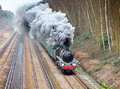
Half hourly passenger trains are operated by Southwest Trains using Class 450 Desiro units. VSOE trains, both steam and diesel, regularly use the route.
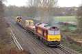
Freight consists of day time engineer�s services between Eastleigh and Hoo Junction. An Enterprise service from Eastleigh to Wembley. Both are operated by DB Schenker. In the afternoon there are empty Gypsum containers from Mountfield to Southampton by GBRf and from January 2007 a Crewe to Southampton Freightliner.
The loop is regularly used at weekends for diverted main line services when there is engineering work between Weybridge and Clapham Junction.The Neasden to Wool sand empties are also routed this way.
Environment
This is a safe environment in open countryside the brick bridge carrying a little used public foot path which joins Watery lane to Ruxbury Road.
The bridge is very close to the M25 Motorway.
Warning: Do not be tempted to enter the field immediately to the South of the line. The land owner does not take prisoners!
The bridge is very close to the M25 Motorway.
Warning: Do not be tempted to enter the field immediately to the South of the line. The land owner does not take prisoners!
Road directions
Click here to set up your location for directions to this location
Watery Lane Bridge map co-ordinates
Parking
Road side in Ruxbury Road or Almners Lane (the section south of Crossing Road) Under no circumstance should you park in Watery Lane. The access to the track from Ruxbury Road is via the unmetalled lane signed to Lynfield Farm. This is opposite a short length of high brick wall. The path is muddy in wet weather. Almners lane is the better option.
Public transport
The nearest Station is Chertsey, this is approximately a 20 minute walk away. There are no public transport links to this location.
Click here to set up your location for directions to this location
Click here to set up your location for directions to this location
Amenities
There is �The Grove� public house in Ruxbury Road, in the Chertsey direction and around a 10 minutes walk. There are no shops nearby. But Chertsey can provide a full range of shops and services.
Sun Compass
Sun Compass using Suncalc by brought to you by Vladimir Agafonkin:
It might be necessary to adjust the time to suit your visit, this link should open with the current day.
Watery Lane Bridge
Streetmap links
Watery Lane Bridge general view map
Watery Lane Bridge close up map
Windows Local Live Link - image quality may vary
Watery Lane Bridge
It might be necessary to adjust the time to suit your visit, this link should open with the current day.
Watery Lane Bridge
Googly map
Watery Lane Bridge general view map
Watery Lane Bridge close up map
Windows Local Live Link - image quality may vary
Watery Lane Bridge
Who likes this location on facebook
Railway Gen Group
Photographic notes
The line runs North West to South East and is good throughout the day for services from Virginia Water. The line from Chertsey is in a curving tree lined cutting and is therefore in shadow for most of the day.
The location is a few hundred yards from the M25, which generates a constant roar making it unsuitable for video/sound recording.
The location is a few hundred yards from the M25, which generates a constant roar making it unsuitable for video/sound recording.
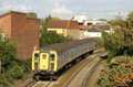
General views - All photographs © Tony Callaghan unless otherwise stated
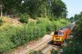
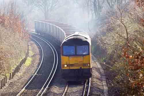
Fig 1 - Looking north west
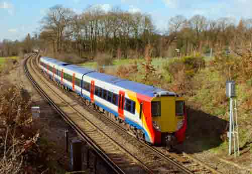
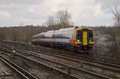
Fig 2 - Looking north west
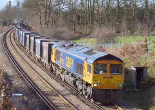
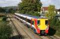
Fig 3 - Looking south east
Disclaimer
All information contained within this is site is � Trainspots. The images used on this site remain the property of the original photographer, as credited at the top of the page, and are used with their kind permission.
The information on these pages is supplied for the benefit of railway enthusiasts who carry out a harmless hobby, and through the medium of photography and video, actually promote the railway industry. Railway enthusiasts can also act as eyes and ears against railway vandalism, and as such should surely be encouraged to do so by the supply of adequate information such as is found on this website.
This site has been created to assist railway photographers in their travels around the country. It is based on the personal knowledge and experience. No liability can be held against the web site or its contributions for incorrect information. Trainspots will endeavour to check all information and corrections will be accepted and posted accordingly.
Advice as to the locations general environment is given as a guide on each page. This information is a GUIDE only. ALWAYS be careful with your equipment, Trainspots can not be held responsible for your personal security. Avoid leaving your property on display for all to see, be aware of your surroundings at all times. There are, sadly, people who will not think twice about trying to steal your equipment.
Trainspots DOES NOT condone trespass and none of the information on this site should be taken as a right to trespass on either railway or private land. To the best of our knowledge all locations are publicly accessible areas, where they are not contact information will be given to the appropriate authority for permission to be obtained.
The content of this site is created and intended for all age ranges but the content of sites linked from this site are not subject to the same intentions. Trainspots will attempt to check links for validity but as time passes and the site grows this will not always be possible. Broken, or indeed updates to, links should be submitted to the editor for inclusion in the updates. All links external to the Trainspots site are opened in a new browser window. Trainspots has been running now for over 10 years and there are imitation sites and guides to railfotspots. But we are a free site and we continue on the path we started out on over a decade ago to provide a useful guide to UK Railway Photographic Locations.