New Mobile Site
We have just launched a new mobile version of this site - m.trainspots. This page will use your smart device's GPS to loctate you and guide you to locations that are close to your present location.
Location notes
As of April 2013 the original bridge has been demolished and has been replaced with a new metal structure a few yards west of the original bridge. Although the shots will not have changed much steps are now essential as the new bridge sides are about 6-7 foot high.
On the Great Western Main Line between Slough and Hayes and Harlington.
On the Great Western Main Line between Slough and Hayes and Harlington.
Railway type and traffic
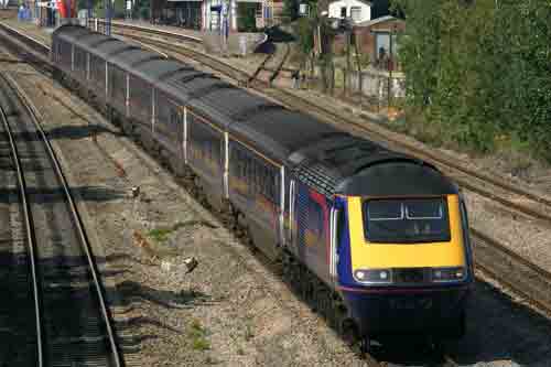
FGW passenger services operated by HSTs, IETs and Class 165/166 Turbos and 387 Electrostars.
There is quite a large amount of freight with that on the mainline consisting of the Mendip Stones to/from Merehead, Whatley and Westbury to Acton Yard and South London. Also DBS hauled stone trains to/from South Wales. You also get the freight coming off the Colnbrook branch which consists of Freightliner hauled Bardon stone trains and the DBS Lindsey - Colnbrook bogie tanks.
There is quite a large amount of freight with that on the mainline consisting of the Mendip Stones to/from Merehead, Whatley and Westbury to Acton Yard and South London. Also DBS hauled stone trains to/from South Wales. You also get the freight coming off the Colnbrook branch which consists of Freightliner hauled Bardon stone trains and the DBS Lindsey - Colnbrook bogie tanks.
Environment
The location is on a footbridge in a slightly rough area, the path/cycleway goes between a housing estate and an industrial estate, although there are undesirables about the footbridge is fairly well used and the policepersons often come over on their bikes.
Road directions
From the M4, Junction 4:
Join the A408 and head north to Yiewsley/Stockley Park. Continue along the road, you will come to a gigantic crossroads with lots of traffic lights, turn left into Lavender Rise, when you come to the children's play park turn left into Porters Way and go past the Air Traffic Control buildings, at the end of Porters Way turn right into Kingston Lane and go past the Primary School, the road becomes the path over the footbridge.
Click here to set up your location for directions to this location
Horton Bridge, West Drayton map co-ordinates
Parking
You can park where the road 'runs out' and becomes the path, but do not leave valuables on show and lock it good and proper <Ed: Good advice for any location!. It is then a couple of hundred yards walk up to the bridge.
Public transport
FGWLink run an hourly service from London/Reading to West Drayton station, there are also regular buses from all over to West Drayton station.
Exit the station on the north side of the line (where the busses call) and turn left, when you reach the High Street turn right, when you cross the canal turn right and join the towpath, follow this along about 500 yard and you reach Horton Bridge which goes over both the canal and the railway line.
Click here to set up your location for directions to this location
Amenities
There are not any toilets on the bridge, but West Drayton high street has eateries.
Sun Compass
Sun Compass using Suncalc by brought to you by Vladimir Agafonkin:
It might be necessary to adjust the time to suit your visit, this link should open with the current day.
Horton Bridge, West Drayton
Streetmap links
Horton Bridge, West Drayton general view map
Horton Bridge, West Drayton close up map
Windows Local Live Link - image quality may vary
Horton Bridge, West Drayton
It might be necessary to adjust the time to suit your visit, this link should open with the current day.
Horton Bridge, West Drayton
Googly map
Horton Bridge, West Drayton general view map
Horton Bridge, West Drayton close up map
Windows Local Live Link - image quality may vary
Horton Bridge, West Drayton
Who likes this location on facebook
Railway Gen Group
Photographic notes
January 2018 Appeal:
The Great Western Electrification continues expanding towards the south-west making most of the GWML shots west of Ealing on the site currently out of date. Please send in your new images of the old locations with the overhead mast and wires in place so people can see how the locations have changed.
January 2014
The new bridge has now had an overhead anti vandal cage fitted making shots from this location very difficult. New images of the bridge and the available shots would be appreciated.
As of April 2013 the original bridge has been demolished and has been replaced with a new metal structure a few yards west of the original bridge. Although the shots will not have changed much steps are now essential as the new bridge sides are about 6-7 foot high.
The line runs almost due east-west here and the line is on a gentle curve through the station. The light is good from when the sun gets up until it crosses the line at around 1600. All lines are photographable, although the mains are a bit nose on, good 'wrong side shots' can be achieved on a cloudy day. You can use both wide angle and zoom lenses here.
Note:Trains comming off/onto the Colnbrook branch go round the back of the station, and you will get advanced warning of their approach by watching the barriers on the branch where a road crosses it into the yard.
Video would be good here although there is quite a lot of noise from the industrial estate, the canal and nearby air conditioning outlets.
General views - All photographs © Kevin Lee unless otherwise stated
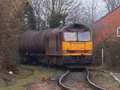
Fig 1 - Looking east
The down relief line
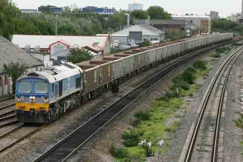
Fig 2 - Looking west
The up main
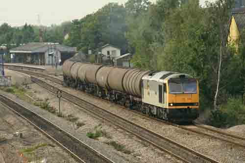
Fig 3 - Looking west
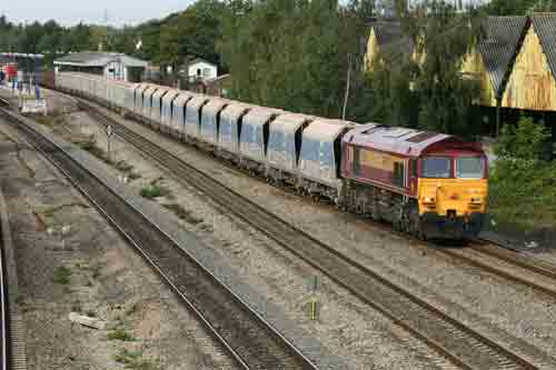
The up relief
Fig 4 - Looking west
An up train leaving the Colnbrook branch
Disclaimer
All information contained within this is site is � Trainspots. The images used on this site remain the property of the original photographer, as credited at the top of the page, and are used with their kind permission.
The information on these pages is supplied for the benefit of railway enthusiasts who carry out a harmless hobby, and through the medium of photography and video, actually promote the railway industry. Railway enthusiasts can also act as eyes and ears against railway vandalism, and as such should surely be encouraged to do so by the supply of adequate information such as is found on this website.
This site has been created to assist railway photographers in their travels around the country. It is based on the personal knowledge and experience. No liability can be held against the web site or its contributions for incorrect information. Trainspots will endeavour to check all information and corrections will be accepted and posted accordingly.
Advice as to the locations general environment is given as a guide on each page. This information is a GUIDE only. ALWAYS be careful with your equipment, Trainspots can not be held responsible for your personal security. Avoid leaving your property on display for all to see, be aware of your surroundings at all times. There are, sadly, people who will not think twice about trying to steal your equipment.
Trainspots DOES NOT condone trespass and none of the information on this site should be taken as a right to trespass on either railway or private land. To the best of our knowledge all locations are publicly accessible areas, where they are not contact information will be given to the appropriate authority for permission to be obtained.
The content of this site is created and intended for all age ranges but the content of sites linked from this site are not subject to the same intentions. Trainspots will attempt to check links for validity but as time passes and the site grows this will not always be possible. Broken, or indeed updates to, links should be submitted to the editor for inclusion in the updates. All links external to the Trainspots site are opened in a new browser window. Trainspots has been running now for over 10 years and there are imitation sites and guides to railfotspots. But we are a free site and we continue on the path we started out on over a decade ago to provide a useful guide to UK Railway Photographic Locations.